Search Term Record
Metadata
Name |
Monuments |
Related Records
-
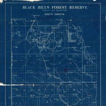
"Black Hills Forest Reserve" Map - February 1899
U.S. Surveyor General's Office map of the Black Hills Forest Preserve dated February 1899. The map is a blue print showing the region from Deadwood in the north to Custer in the south. East of Deadwood, the map is divided into what appear to be plats. The heading reads: "Black Hills Forest Preserve / Proclamation dated September 19, 1898 / South Dakota" A white label on the bottom right reads: "Office Map / Drawer K No. 67 / Return to Fran...
Record Type: Archive
-
-
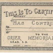
Grier Memorial Fund Certificate - 1915
Two certificates acknowledging that John Striegel and Mrs. Striegel of Deadwood had donated to the Grier Memorial Fund in February of 1915. The certificate has a photograph of T.J. Grier on it.
Record Type: Archive
-
-
-
-
-
-
-
