Archive Record
Images
Metadata
Title |
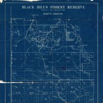
"Black Hills Forest Reserve" Map |
Date |
February 1899 |
Scope & Content |
U.S. Surveyor General's Office map of the Black Hills Forest Preserve dated February 1899. The map is a blue print showing the region from Deadwood in the north to Custer in the south. East of Deadwood, the map is divided into what appear to be plats. The heading reads: "Black Hills Forest Preserve / Proclamation dated September 19, 1898 / South Dakota" A white label on the bottom right reads: "Office Map / Drawer K No. 67 / Return to Frank Peck, Deadwood, S.D." |
Collection |
Adams Museum Collection |
Object Name |
Map |
Catalog Number |
ARC.2007.041.001 |
Extent of Description |
1 map (22.5" x 36") |
People |
Peck, Frank S. |
Search Terms |
1890s Maps Black Hills Black Hills National Forest Mining Stagecoach Trails Monuments |