Photo Record
Images
Additional Images [2]
Metadata
Title |
MISCELLANEOUS, Fires, Floods, Tornados |
Date |
1962-1965 |
Description |
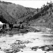
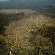
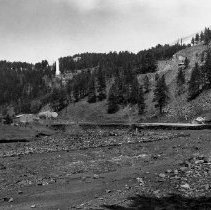
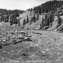
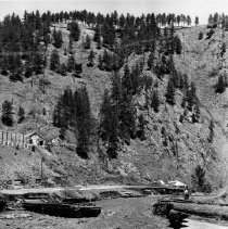
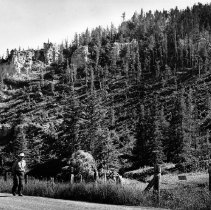
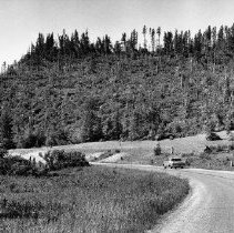
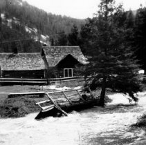
Series of photographs of fires, floods, and tornados. 330-1: Mine Fire Flooding. There is a tent with several men and women standing looking at the water. 330-6: Aerial view of the hills and a road. The photograph was taken on July 20, 1962 after the June 20, 1962 tornado. 330-9: View of the damage of Kirk Road and the Black Hills Power and Light Company's Kirk Plant after a flood, 1965. Sharp Bits October 1965 Vol. 16 No. 9: "State and County Highways throughout the Black Hills took a terrible beating following the torrential rain that fell starting May 14, 1965. Here the angry flood water has completely wiped out the Kirk Road, south of Lead. At left is Black Hills Power and Light Company's Kirk Plant." 330-10: Kirk Road south of Lead, 1965. Sharp Bits June 1965 Vol 16 no 5: "The forces of nature (a wet spring snow followed by torrential rain) wreaked havoc along the streams and in most of the towns or the Northern Black Hills. Hardest hit were Spearfish, Sturgis, and Deadwood. Estimates of the damage in the area run into the millions of dollars. Here is the angry water has completely wiped out the Kirk Road, south of Lead." 330-11: Kirk Timberyard flood, 1965. Sharp Bits June 1965 Vol 16 no 5: "The Kirk Timberyard at our Black Hills operations was left high and dry following the disastrous flood of May 15-16, 1965. This photo was taken May 16 when the water was receding, shows how the highway and bridge approaches to the yard were completely destroyed. At the right, a second of Chicago, Burlington and Quincy R.R. track is about to drop into the stream." Sharp Bits October 1965 Vol. 16 No. 9: "Whitewood Creek which drains much of the Terry Peak area, west of Lead, wreaked havoc with the Chicago, Northwestern Railroad in lower Deadwood. It also destroyed much of the highway in this canyon, and most of the bridges, including the one shown here at our Kirk Timber Yard." 330-14: View of a man walking on the road next to the hills, 1965. There is a sign attached to a fence that reads "KEEP OUT // H.M. Co." 330-15: View of Spearfish Canyon, adjacent to the Homestake Mining Company's water intake after the July 12 tornado, 1965. Sharp Bits October 1965 Vol. 16 No. 9: "A tornado smashed a 20-mile path through a heavily wooded area southwest of Lead on July 12, 1965. About 6,400 acres of timberland were leveled, one-fifth of this total being on land owned by us. This scene is Spearfish Canyon is adjacent to he Homestake water intake. Fortunately, no loss of life or injuries resulted from this storm." 330-19: Cabin near Cheyenne Crossing in Spearfish Cabin six days after a blizzard, 1965. Sharp Bits October 1965 Vol. 16 No. 9. "A few patches of snow were still visible when this scene near Cheyenne Crossing in Spearfish Canyon was photographed on May 14, 1965, only six days after the blizzard. The footbridge didn't wash away only because it was cabled to the spruce tree in the foreground." |
Collection |
Homestake Mining Company Collection |
Object Name |
Series, Archival |
Catalog Number |
HMCC 330 |
Print size |
Please See Metadata for Print Sizes |
Search Terms |
1960s Aerial Photography Aerial View Black Hills Power & LIght Company Bridges Cheyenne Crossing Chicago Burlington & Quincy Railroad Fires Floods Homestake Mining Company Kirk Power Plant Kirk Road (Lead, S.D.) Kirk Timberyard Lead Men Railroads Sharp Bits Spearfish Canyon Tornados Trees Water Women |