Search Term Record
Metadata
Name |
Maps |
Related Records
-
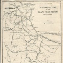
Automobile Map of the Black Hills Region
An undated map of the Black Hills in South Dakota and slightly over the border into Wyoming. The back of the map has Association of Black Hills Commercial Clubs Secretaries letterhead on it. The Black and Yellow Trail is marked on the map.
Record Type: Archive
-
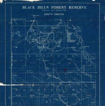
"Black Hills Forest Reserve" Map - February 1899
U.S. Surveyor General's Office map of the Black Hills Forest Preserve dated February 1899. The map is a blue print showing the region from Deadwood in the north to Custer in the south. East of Deadwood, the map is divided into what appear to be plats. The heading reads: "Black Hills Forest Preserve / Proclamation dated September 19, 1898 / South Dakota" A white label on the bottom right reads: "Office Map / Drawer K No. 67 / Return to Fran...
Record Type: Archive
-
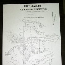
Fort Meade Military Reservation Plans - 1879-1883
Four copies of a ground plan drawing the survey of the Fort Meade military reservation. Surveying was done by Major H.M. Luxette of the U.S. Infantry. Shows distances along boundary lines and notes the latitude and longitude at flagstaff. Total area on the map is 4848 acres. Shows Bear Butte Lake, Fort Meade, Bear Butte Creek, location of Sturgis, trails to Deadwood, Rapid City and Bismarck and topography of the region.
Record Type: Archive
-
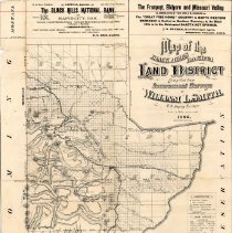
"Map of the Black Hills Dakota Land District" by William L. Smith - 1886
"Map of the Black Hills Dakota Land District" by William L. Smith from a promotion for the First National Bank of Rapid City. Features the Fremont, Elkhorn, and Missouri Valley Rail Line.
Record Type: Archive
-
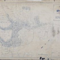
Map of the City of Deadwood, Lawrence County, S. Dak - 1891
Map of the City of Deadwood, Lawrence County, S. Dak. showing boundary of City limits and Wards; also lots, blocks, streets, mineral claims, prominent buildings, and street and railroad lines. Drawn by P.L. Rogers, City Engineer of the City of Deadwood, on January 5, 1891. The map was made the official map of the City of Deadwood on January 5, 1891. The legend depicts lines for Patented Mineral Claims, Rail Roads, and Street Railroads. ...
Record Type: Archive
-
-
-