Archive Record
Images
Metadata
Title |
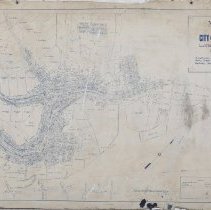
Map of the City of Deadwood, Lawrence County, S. Dak |
Date |
1891 |
Scope & Content |
Map of the City of Deadwood, Lawrence County, S. Dak. showing boundary of City limits and Wards; also lots, blocks, streets, mineral claims, prominent buildings, and street and railroad lines. Drawn by P.L. Rogers, City Engineer of the City of Deadwood, on January 5, 1891. The map was made the official map of the City of Deadwood on January 5, 1891. The legend depicts lines for Patented Mineral Claims, Rail Roads, and Street Railroads. There are pencil markings throughout the map that help clarify some of the smaller print street names. There is a red mark on a couple of lots on Main Street near the School building, that the donor noted is where her family lived. The Street, names, and places that are features on this map can be found in the People and Search Term Tabs. The following Mineral Claims, and Placer claims found on the map are as follows: M.C. 45 M.C. 53 M.C. 71 M.C. 72 M.C. 75 M.C. 78 M.C. 81 M.C. 86 M.C. 97 M.C. 207 M.C. 216 M.C. 249 M.C. 283 M.C. 308 M.C. 335 M.C. 343 M.C. 686 Hill Claim No. 2 Hills Claims 13, 14, and 15 P.C. 2 P.C. 2-1/2 P.C. 3 P.C. 14 P.C. 15 P.C. 16 U.S.L.M. No. 2 |
Collection |
Adams Museum Collection |
Object Name |
Map |
Catalog Number |
2023.028.001 |
Extent of Description |
28 inches x 18 inches |
People |
Bauman, Matilda Burling, James Burner, Charles Burnham, John Burton, Sam S. Chase, J. Dudley, E.G. Fargo, C. Fink, Joseph Fork, J.W. Fox, A. Guild, John Hunter, E. Hunter, John Ickes, Frank E. Kelly, Jacob S. Kiddebrand, L.F. Marble, Sarah McLaughlin, Ellen Moody, G. C. Moody, Judge Gideon C. Myrrick, J.M. Norton, Frank Parker, W.H. Pennel, William Porrers, P. Porrers, T. Pratt, W. Rogers, P.L. Rolvant, Frank Shrader, W.B. Smith, Alex Smith, Joseph S. Treber, John Volin, Joseph Whistler, W. |
Search Terms |
1890s Adams Street Buchanan Street Burnham Avenue Carney Street Cemeteries Centennial Avenue Charles Street Churches City Creek Civilizer Gulch Dakota Street Deadwood Deadwood Central Railroad Deadwood Creek Deadwood Schools Deadwood Street Dunlap Ave Emery Street Filmore Street First Ward Fish & Hunter Company Forest Avenue Franklin Street Guy Street Harrison Street Highland Ave Jackson Street Jefferson Street (Deadwood, S.D.) Lee Street (Deadwood, S.D.) Lincoln Avenue Madison Avenue Main Street Main Street, Lower Main Street, Upper Maps McLaughlin Street Miller Street Minnesota Street Mount Moriah Cemetery Park Street Pearl Street Peck Street Phillips Street Pine Street Pleasant Street Pollock Street Railroads Schools Sherman Street Shine Street Spring Creek Spruce Gulch Star Street Stewart Street Summit Avenue Taylor Avenue Terrace Street Toll Gates Treber Street Valley Avenue Van Buren Street Wall Street Washington Street Whitewood Creek Williams Street |
Archival History |
The donor found the map on some shelves in their parents storage room after they passed away. The family purchased the house on 781 Main Street from the Carrs. The donor does not know how they got the map. |