Photo Record
Images
Additional Images [15]
Metadata
Title |
TOWNS/MISC. SCENIC & GEOGRAPHIC, Lead, General Views No. 1 |
Date |
1876-1914 |
Description |
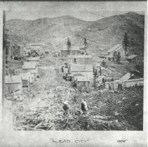
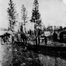
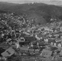
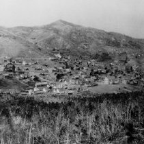
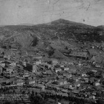
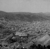
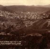
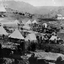
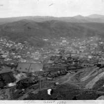
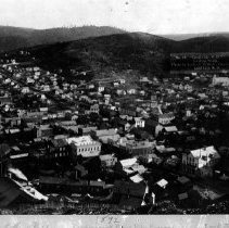
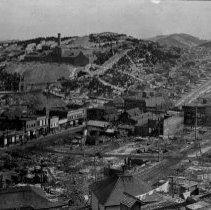
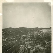
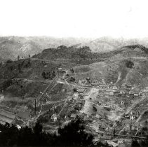
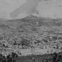
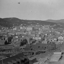
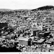
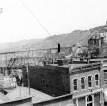
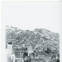
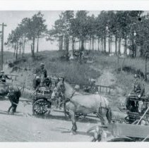
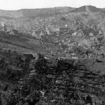
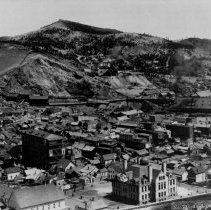
Series of photographs of general views of Lead. 478-1: Lead City, 1876. 478-2: Lead City, 1876. Written on the bottom of the photograph is "Lead City, Oct. 8, 1876. A.M. Cox. Propr. of St. James Hotel." 478-4: Lead City; This scene was taken from what is now part of the open cut. Date between 1884-1888. The Hearst is located in the first large building in the center of the foreground. Mill St. stretches from the upper left corner to the lower right. Main St. runs from left to right. The kittenball (what?) field would later be located across Main. St. and at the left of the picture. The large building is the distance at the right is the school located on the Central Campus. Sharp Bits July 1960 Vol. 11 No. 6 pg. 31 top "Various historians have placed different dates on this photo, ranging from 1885 to 1892. One reason for believing that it was in the middle or late '80s is that the "City" portion of Lead's name was officially dropped in 1890. At any rate this was taken from the vincinity of the B. & M. No. 1, and clearly shows South and North Mill Streets and South Bleeker Street. Compare this to the two other views (from the same location at different dates) on facing pages near the front of this issue." 478-6: Lead, 1880s. 478-7: Overhead view of Lead City, looking north-east, with Homestake Mills and Mines in the distance. View of the open cut. Gold Street block east of wall in lower hand corner. Photograph was probably taken in the 1880's. The photograph was taken by C.C. McBride, Deadwood, S.D. 478-8: Lead S.D. looking south west. 478-10: Overhead view of Lead City, Dakota Territory, 1888. The photograph is captioned with "The Great Mining Centre of the Black Hill's Lead City, D.T. 1888." The photo by Coules & McBride. Sharp Bits January 1962 pg. 10-11 Sharp Bits November 1966, Vol. 17, No. 10 pg. 3 "Taken only twelve years after its founding this photo shows Lead City, Dakota Territory a "beehive" of activity. Smoke pours from the backs of the pounding stamp mills then located north and east of the corner of Mill and Main Streets. Population of Lead City at that time was about 3,000. Six churches were in operation and 400 students were enrolled in the public school system." 478-12: Grand Army of the Republic encampment at the top of Mill Street for their reunion, 1890. Sharp Bits January 1962 Vol. 12 No. 12 pg. 5 "The Grand Army of the Republic had a reunion for Black Hills members in Lead in 1890. This is their encampment at the top of Mill Street, looking south." 478-13: Amicus Golden Star Homestake, ca. 1890. 478-14: Lead S. Dak., 1892. 478-15: Aftermath of the 1900 Fire. 478-16: Overhead view of Lead. 478-17: Overhead view of lower Lead and the No. 1 Cyanide Sand Plant, 1902. The photograph is captioned with "Cyanide at Lead." Sharp Bits Summer 1968 Vol. 19 No. 2 pg. 32 "The year was 1902. The one-year-old plant was the No. 1 Cyanide Sand Plat in Gold Run Gulch in lower Lead. Coal to fire the heating and other boilers came in by rail above, and was then relayed down the incline chute. Today the Yates Shaft Unit, the Mechanical Department Shops, the South Mill, the Refinery and the West Cyanide Sand Plant give this hillside an entirely different appearance." 478-19: Overhead view of Lead. 478-21: Overhead view of Lead. 478-23: Overhead view of Lead. 478-24: View of Lead from Smead Hotel. Mill Street, Flag Rocks (Top Center), TJ Grier Residence, Ellison Hoist (Upper Rt) can be seen. Written on the back is "Charles Ricker." 478-25: View of south Siever Street looking north. City Hall can be seen in the center of the photograph. Written on the back of the photograph is "31. South Siever St. Looking North // Note City Hall Center (Homestake Office) // Charles Ricker." 478-26: Men on horses and wagons (possibly hook and ladder wagons) on upper Main Street on July 4th, 1914. Written on the back of the photograph is "6. Upper Main Street, July 4th, 1914 // Charles Ricker." 478-27: View of Lead looking northwest from Flag Rocks. Bald Mountain can be seen on the upper left over the Ellison Hoist. 478-28: Overhead view of Lead, 1902. Sharp Bits January 1962 Vol. 12 No. 12 pg. 16-17 "The date on the back of this old photo said "about 1902" The large building (with many porches on the rear) was the Miners Union. The first National Bank of the Black Hills is now located here. // Notice the wood chutes and the enormous piles of "unstacked" wood. This was more than enough to make any boy's back ache. But wood was needed in great quanitity to fire the boilers at the shafts and mills." |
Collection |
Homestake Mining Company Collection |
Object Name |
Series, Archival |
Catalog Number |
HMCC 478 |
Print size |
Please See Metadata for Print Sizes |
People |
Coules & McBride McBride, C.C. Ricker, Charles |
Search Terms |
1870s 1880s 1890s 1900s 1910s Amicus Mill Animals Automobiles Bald Mountain Buildings Camps Cyanide Mills Cyanide Plant Cyanide Plant No. 1 Ellison Hoist Flag Rock Shops Fourth of July Gold Run Gulch Gold Star Mill Grand Army of the Republic Grier Mansion Homestake Cyanide Plant #1 Homestake Gold Mine Homestake Mining Company Homestake Office Building Horses July 4th Lead Lead City Main Street, Lead Men Mill Street Miners Union Hall Open Cut Sharp Bits Siever Street Smead Hotel Wagons |